
This page was copied from: http://www.suat.demon.co.uk/elgin_bs/elgin_a1.htm for informational and historical purposes. Please note original copyright at bottom of page. Duffuses had an early presence in Elgin.
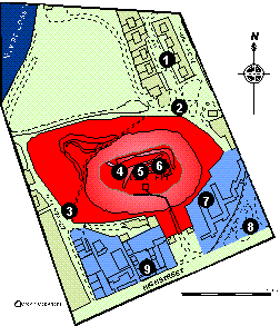
This area is defined by High Street to the South, the old course of the River Lossie to North, the West side of Hill Street and the relief road to the east. It contains the site of the medieval castle on Ladyhill and the site of the Dominican Friary.
Click here for a full size map (33K)
The Blackfriars house in Elgin is thought to have been founded by Alexander II between 1233 and 1235. The Ordnance Survey location is approximate, but it is certainly known to have occupied part of the "Borrowbriggs" (lands that extended north from Blackfriars Street to the River Lossie). A documentary reference of 1851 states that ruins of the Blackfriars buildings were visible at the west end of the "Borrowbriggs", to the south of a pool or pond (stank) formed by the River Lossie. However a letter of 1789 claims that all the buildings were "rased and made arable" in 1750 (Simpson and Stevenson 1982, 30).
Excavations on the reputed site of the Blackfriars monastery stank uncovered 50 skeletons c 0.45 m below modern ground level. These skeletons lay at random and there was no sign of any coffin nails. (Keillar 1971, 30).
Recent work close to the public weighbridge has located human skeletal remains. These may represent the bodies of people who were executed on the gallows that formerly stood in this vicinity (pers comm I. Shepherd).
Excavations in 1858 by Elgin Literary and Scientific Association were carried out just outside the outer walls of the castle. Three skeletons were discovered, a flint arrowhead, several sherds of pottery, a quern and a copper coin of Charles II. (Shaw 1882, II, 7; MacKintosh 1914, 174).
Excavations in 1973 by the DOE located structural fragments of dressed and mortared stone and some postholes. A cutting to the north located a possible rampart strengthened by tipped stone with a vertical timber revetment. This latter feature may represent the curtain wall of the medieval castle. Quantities of medieval pottery and animal bone were located and some small finds (MacDonald 1973, 38).
The first mention of a castle is in 1160 in a land grant. Its early importance is reflected by its royal connections, for example William the Lion granted several charters from this castle. The castle was damaged in 1297 by the Scots who took it from Edward I. It was possibly dismantled at the end of 13th century as there is a reference to alternative accommodation being found in the burgh. There must have been some reconstruction as it is again mentioned in charters of the 14th and 15th centuries. The circumstances of the castle's abandonment are obscure but its chapel was certainly in use until 1556 (Simpson and Stevenson 1982, 35).
Trial excavations in 1976 by W. J. Lindsay in advance of the new relief road located deep garden soil. A stone drainage tank was found.
Trial excavations in 1986 by SUAT in advance of new housing located natural sand at c 0.2 m below modern ground level (Hall 1986, 11).
Trial excavations in 1976 by W. J. Lindsay in advance of the new relief road located natural at c 0.60 m below modern ground level.
The excavations of 1858 and 1973 on Ladyhill indicate the presence of archaeological deposits here. Future development of the site seems unlikely, but any proposals would require an archaeological response to record any further information regarding this little understood site, especially in relation to the castle.
From the limited work on the High Street frontage (nos 7, 8, 9) deposit survival seems to be very poor, however all opportunities to verify this by further assessment should be taken.
The site of the Blackfriars convent (no 1) is of unknown potential; the ordnance survey locates it in Bibby Place, but there is no record of anything being recovered during the construction of this housing development (pers comm I. Shepherd). Any proposals for the redevelopment of the green field site centred at NJ 2105 6295 would require an archaeological assessment to see if the friary stood in this area. It is also worth noting that this area is said to be part of the original site of the burgh before it was burnt down. It is claimed that this event took place after a battle between the Earls of Moray and Huntly in 1452; the Earl of Huntly's troops burnt down the half of the town of Elgin which was siding with the Earl of Moray (Shaw, 1827, p 263).
Copyright © Scottish Urban
Archaeological Trust Limited
55 South Methven Street, PERTH, PH1 5NX
Tel: +44 (0)1738 622393
Fax: +44 (0)1738 631626
E-Mail: derekh@suat.demon.co.uk