 Elgin: Area 4
This page was copied from: http://www.suat.demon.co.uk/elgin_bs/elgin_a4.htm for informational and historical purposes. Please note original copyright at bottom of page. Duffuses had an early presence in Elgin.
 Elgin: Area 4

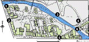
Defined by High Street to the south, Lossie Wynd to the west, an arbitrary boundary to the north and the western side of the cathedral precinct to the east.
Click here for a full size map (28K)
Excavations in 1977 in advance of the new relief road cut a section across the theoretical line of a boundary ditch. Excavation revealed an 8 m wide by 1 m deep watercourse which had been recut three times in the 15th and 16th centuries. This feature may have been utilised as the northern boundary to the burgh. A 16th century stone built well was also located. (Lindsay 1977, 24).
This port was demolished in 1787 (Simpson and Stevenson 1982, 19).
Trial excavations in 1976 in advance of the relief road located natural sand at c 0.80 m.
Further trial excavations in 1976 in advance of the relief road located natural sand at c 0.60 m.
This monument was first erected in 1402. It has been suggested by Dr R. Cant that it may represent a market cross for a settlement dependant on the cathedral, although there is no proof of this (Cant 1974, 9).
Excavations in 1976 in advance of the relief road located a well and several hearths and pits of late medieval date. Considerable quantities of pottery and iron slag were recovered from these features. One of the pits contained painted window glass from the cathedral. (Lindsay 1976, 44).
There have been no excavations on the street frontage in this area and therefore the scale of preservation is not known. The two Relief Road excavations at Lossie Wynd and North College Street located late medieval deposits at some distance from a major street frontage.
It has been argued that this part of Elgin developed as a result of secondary burgh expansion in the 14th century (Simpson and Stevenson 1981, 21). It would be very useful to test this by further excavation particularly in the area between High Street/Lossie Wynd and Alexandra Road. The two trial trenches in the Cooper Park (nos 3 and 4) suggest that this area has always been open ground.
Copyright © Scottish Urban
Archaeological Trust Limited
55 South Methven Street, PERTH, PH1 5NX
Tel: +44 (0)1738 622393
Fax: +44 (0)1738 631626
E-Mail: [email protected]