 Elgin: Area 8
This page was copied from: http://www.suat.demon.co.uk/elgin_bs/elgin_a8.htm for informational and historical purposes. Please note original copyright at bottom of page. Duffuses had an early presence in Elgin.
 Elgin: Area 8

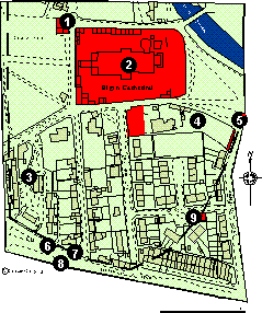
Defined by the western, northern and eastern limits of the cathedral precinct, and by South College Street to the south. It contains the cathedral, part of the cathedral precinct and the Bishop's House.
Click here for a full size map (36K)
This building is misleadingly named as it was actually built for the precentor of Elgin. It is dated to 1557 although it is probably a composite construction (Fawcett 1994, 281).
The cathedral of the Bishopric of Moray was formally established beside Elgin in 1224. There is some evidence that the church of the Holy Trinity was at least partly in existence when it became the cathedral. Prior to 1224 it is referred to both in a bull of Pope Honorius III and a charter of King Alexander II as the church of Holy Trinity beside Elgin (Simpson and Stevenson 1981, 7). The cathedral was burnt down in 1270, and was subsequently rebuilt with a chapter house. Burnt down again in 1390 by the Wolf of Badenoch, it was restored in the mid 15th century. By 1567 there are orders to remove the lead from the roof, suggesting that the cathedral was in decline. The manses of the secular canons were grouped around the cathedral within the precinct, enclosed by a stone wall that had four gates through it, the only one that still survives being the Pans Port (see Area 9) (NJ 2231 6297) (Simpson and Stevenson 1982, 27).
Excavations by W.J. Lindsay in 1977 in advance of the relief road located late medieval pits and industrial features cut into natural sand.
Trial excavations by SUAT in 1987 located c. 2 m of garden soil above natural sand. Two small cut features containing bone, shell and fragments of medieval pottery were located. (Hall 1987, 24).
This former access to the cathedral precinct was much restored in 1857. There also survives a small portion of wall attached to it (Simpson and Stevenson 1982, 29).
Trial excavations by W. J. Lindsay in 1976 located c 0.7 m of garden soil over natural sand. This soil contained medieval pottery.
Trial excavations by W. J. Lindsay in 1976 located natural sand at 0.5 m.
There is a reference to an east port of the burgh as early as 1242 (Shaw 1882, III, 66). It has been argued that this port previously stood to the east of St Giles Church (NJ 2172 6287) where the High Street narrowed, and that it was moved when the burgh extended to the east sometime before the 15th century (Cant 1976, 9), but there is no proof for this hypothesis. The port stood on the documented site until its demolition in 1795.
This short fragment of wall (8.5 m) stands 2.7 m high and defines the course of the precinct wall to the south west (Simpson and Stevenson 1982,30).
The limited work within the cathedral precinct suggests that archaeological deposits may survive very well under deep deposits of garden soil. Stretches of the former precinct wall may be located to the west of Collie Street, running through the Cooper Park and in the housing estate to the east of Cathedral Road. The sites of a number of the cathedral manses were in the area now occupied by King Street, and any redevelopment in this area should be closely monitored. The excavations at Lazarus Lane (no 3) indicate that deposits relating to the late 14th century burgh expansion may also survive in this area.
Copyright © Scottish Urban
Archaeological Trust Limited
55 South Methven Street, PERTH, PH1 5NX
Tel: +44 (0)1738 622393
Fax: +44 (0)1738 631626
E-Mail: [email protected]